Mars Rover Snapped From Orbit
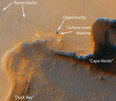
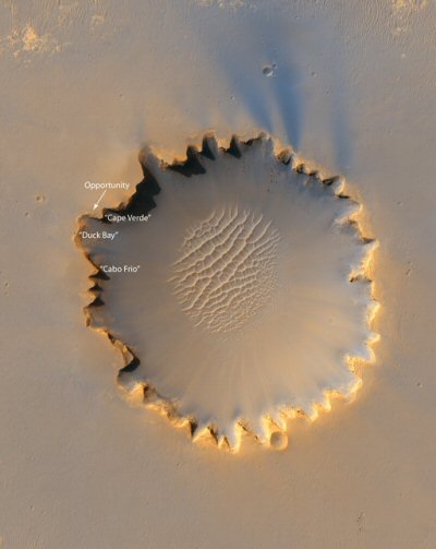
A high resolution camera on NASA's Mars Reconnaissance Orbiter has taken a remarkable picture that shows the exploration rover Opportunity poised on the rim of Mars' Victoria crater.

"We're poised to have a fantastic mission, and we're not even at prime science mission yet," said Alfred S. McEwen. "This was our very first attempt to image 'off-nadir' (at an angle as opposed to straight down), and it worked fabulously well," he added. "It's been an exciting week."
Alfred S. McEwen, of the University of Arizona (UA) Lunar and Planetary Laboratory, is principal investigator for The High Resolution Imaging Science Experiment (HiRISE), which is operated from UA's Lunar and Planetary Laboratory in Tucson.
The rover Opportunity drove more than five miles to get to Victoria crater, an impact crater at Meridiani Planum, near Mars' equator. The HiRISE camera took its picture five days later, at 3:30 p.m. local Mars time, as the sun was about 30 degrees above the horizon, illuminating the scene from the west. The NASA orbiter was flying 186 miles above the planet's surface. McEwen said that the HiRise camera could resolve objects that are 35 inches across at that altitude.

HiRISE's impressive overview of Victoria crater shows a distinctive scalloped shape to its rim. This is formed by eroding crater wall material moving downhill. Layered sedimentary rocks are exposed along the inner wall of the crater, and boulders that have fallen from the crater wall are visible on the crater floor. A field of sand dunes covers much of the crater floor.
"The ground-truth we get from the rover images and measurements enables us to better interpret features we see elsewhere on Mars, including very rugged and dramatic terrains that we can't currently study on the ground," McEwen said. "Stay tuned," McEwen said at the NASA briefing. "If you think this HiRISE image is spectacular, just wait."
More pics from the University of Arizona.
Source: University of Arizona


No hay comentarios.:
Publicar un comentario